Location
Goatstown is a south Dublin dormitory suburb located within the metropolitan Dublin area, 7.5Km south-east of St Stephen’s Green and nine kilometres south of Dublin City Centre. The local authority for Goatstown and surrounding areas is Dún Laoghaire-Rathdown County Council.
Although a well-known neighbourhood, Goatstown lacks a definitive centre and is mainly associated with a public house and restaurant – The Goat at ‘Goatstown Cross’ – the Taney Road/Mount Anville Road/Goatstown Road/Drummartin Road junction. Proposals were recently presented for comprehensive redevelopment of ‘The Goat’ site.

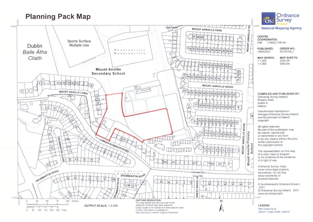
Reproduced under licence CYAL50166725 © Ordnance Survey Ireland/Government of Ireland.
The subject lands are located on the north side of Kilmacud Road Lower’s most western extremity, approx. 250m north-east of Kilmacud Road Lower’s junction with Drummartin Road, 500m north-east of The Goat – and between Nos. 245 and 257 Kilmacud Road Lower. Dundrum Town Centre is 2km south west, Stillorgan Shopping Centre 2km East and University College Dublin 2.5km north-east. The lands lie midway between the public park at Deerpark (Mount Merrion) and Airfield Estate (Dundrum); and close to UCD grounds at Belfield. Marlay Park and access to the foothills of the Dublin Mountains is within 5km. Within a 5.5km radius there are a significant number of well-known golf clubs – Castle/Milltown /Elm Park/Foxrock and the coast at Blackrock (4km) and Dun Laoghaire (7km) is easily accessible.
The existing access road to the lands is shared with Mount Anville Schools as a pedestrian entrance/exit and a short vehicular entrance to a housing development– the Sophie Barat Residence – containing 28 modern bungalows, Sophie Barat caters for past pupils, male and female, of all Primary, Junior and Secondary Sacred Heart schools including former teachers, brothers or sisters of past pupils and children of those who attended Sacred Heart schools.
The Goatstown/Kilmacud area was substantially developed as in the 1960’s and 1970’s with later infill development. The immediate area is almost exclusively residential with terraced, semi-detached, and detached, two storey houses.
Goatstown is an important confluence of a number of major radial and orbital routes that pass through the County of Dún Laoghaire-Rathdown providing easy access north/south and east/west – the main southern access route to Dublin city (N11) is 2.5km east and access to Dublin’s orbital motorway, the M50, is 2.5Km south at the Sandyford junction.
Public transport in the area is good – Kilmacud West LUAS (tram) Station is approx 1km to the south and Dublin Bus route 11 serves Kilmacud Road Lower and Drummartin Road – stops 3019 and 3021 – at 20-minute intervals. The proposed ‘Bus Connects’ public transport bus upgrade includes a 10-minute bus route frequency at Mount Anville Road and Drummartin Road.
New developments in the immediate area include Knockrabo (Mount Anville Road) – houses and apartments and Trimbleston (Goatstown Road) – apartments.
The property comprises the Old Farmhouse and adjoining lands together with the South Lower Walled Garden as outlined in Appendix 2 – in total, we are advised, 2.87 acres (1.16 hectares). Due to the need to retain rights of access/egress the lands are severed and therefore essentially in two parts. The lands are adjacent to the rear gardens of houses on a section of Lower Kilmacud Road and Mount Anville Lawn with those at Mount Anville Lawn most proximate to potential development on the lands. The adjoining Sophie Barat housing (28 bungalows) and the Mount Anville Schools share the existing access road.
A Heritage Appraisal (22 April 2020) prepared by Hanna Loughnane BArch MRIAI of Five- Seven Architects, states:
“…the second (southerly) walled garden has already been compromised by the development of housing along its southern boundary which has resulted in the loss of the southwest corner of the garden. No buildings of note remain in this garden and the landscaping layout is probably not original.”
In relation to the Old Farmhouse the Heritage Appraisal states:
“Although unoccupied at present and somewhat neglected, the original courtyard arrangement of the Victorian farm buildings is still evident.”
A copy of the Heritage Appraisal is provided in the Data Room
We are advised that The Old Farmhouse building is in poor condition and beyond its economic life. It is a part two storey Victorian building with mid-20th Century single storey extensions. Although originally part of a complex of courtyard buildings in a traditional farming context, all the other courtyard buildings are long since demolished.
Boundaries are mainly defined by the open nature of lands to the north-east/east (towards schools), south by Sophie Barat Residence and the south and west by and the boundary walls of adjoining houses. The Old farmhouse section of the site addresses Kilmacud Road Lower (west).
As mentioned previously, roads need to be to a standard to accommodate any future development of adjacent lands and to DLRCC’s ‘Taking in Charge’ standards.
